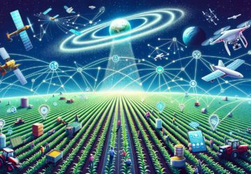
Do you hear about drones in crop insurance?
Do you hear about innovative car insurance at that times, when insurers started to use cars to reach incident place? Or maybe do you know about computer-based insurance because claim adjusters started to use computers and databases to store information about clients, properties, and claims?
We are sure, that wide using drones and autonomous machines in the insurance will be mentioned in the near future as something ordinary, like using cars, computers or even paper in the insurance process.
Crop underwriting and claims auditing are processes that are both time and cost-consuming, and providing assessment manually often leads to inaccurate loss estimates. And the penetration of autonomous machines in the insurance industry is unavoidable and AI-powered drones present a whole new level of risk assessment possibility for agricultural insurers.
We would like to show an example of drone application with further processing in Skyglyph cloud system.
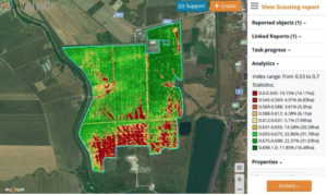
Client claimed of a 140 h.a. field after a massive flood. It was very difficult for a claim adjuster to measure all zones manually and his report showed 40% damage.
With help of drones was provided visual and NDVI (Normalized Difference Vegetation Index) orthophotos. NDVI photo allows showing the health of a crop according to a color scale, where green color means maximal health and red indicates an absence of vegetation.
The system indicated only 26 ha (18%) of the crop was severely damaged (22% or 30ha less).
Thus, using drones and Skyglyph analytical tool led to savings of loss payout.
About Skyglyph . The main direction of our business is developing cloud-based software (Skyglyph) for assets monitoring from drones. Our first industrial application on the base of Skyglyph allows insurance companies to integrate drones and satellites into their business processes more easily. Insurers can use Skyglyph to detect and assess crop and property damages from images, collected by drones, satellites and even smartphones. It means an acceleration of claim processing, saving money and avoiding fraud.