Simply draw border of required area
in the our system.
Turn aerial images into data and information for decision making through
our intelligence images recognition and interpretation.
 Aerial MappingYou receive of ortophoto - map of your fields, house, factory or other asset
 Site InvestigationYou receive of ortophoto - map
of your fields, house, factory or other asset + detailed 1 m distance photos or video on-site objects or its details
Site InvestigationYou receive of ortophoto - map
of your fields, house, factory or other asset + detailed 1 m distance photos or video on-site objects or its details 3D modellingBuild 3d model of your asset, including houses, fields, cars, etc.
 BIMBuild an Informational Model of assets.
Add physical or functional characteristics
of assets to orthopoto or 3D model
BIMBuild an Informational Model of assets.
Add physical or functional characteristics
of assets to orthopoto or 3D model RAMRemote Asset Management. Monitoring time from time certain characteristics of assets and detect assets changes or risky situations
 CSVCustom Street View. Generate 360 Degree Panorama with ability of virtual journey
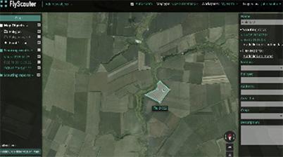

Operatively collect, process, store, analyse and delivery of photo and video materials with help of skyglyph - our Aerial Scouting Cloud Platform

Get new, unseen before, view on your business by getting recognition and interpreation of your aerial images

You do not need drones, special equipment, trainedpersonnel and power servers
Write us
[email protected]Also you can contact us here
Telegram: SkyglyphVisit us
36 Vitosha Blvd., apt. 8More about on social media


