You get aerial map of your field, delivered to your computer
in the couple days directly from field with precision up to 2 cm/pixel.
Also we provide you additional professional sevices
from our agri-consultants.
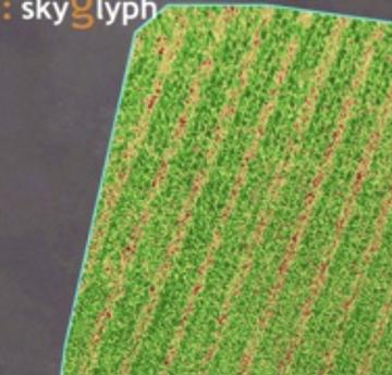
 Visual Crop Map EvaluationDetect and track plants diseases, weeds and crop damages
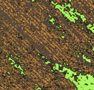
 Crop health maps – NDVIIdentify problem areas and variations on the your fields
Decreasing in NDVI values during the active growing: indicates stress crops due to natural phenomena (hail, rainstorms, drought), as well as damage by pests, deficit of fertilizers .
Reducing NDVI in other periods: shortage of soil moisture, deficit of fertilizers, weeds
Crop health maps – NDVIIdentify problem areas and variations on the your fields
Decreasing in NDVI values during the active growing: indicates stress crops due to natural phenomena (hail, rainstorms, drought), as well as damage by pests, deficit of fertilizers .
Reducing NDVI in other periods: shortage of soil moisture, deficit of fertilizers, weeds  Nitrogen maps – gNDVI- Detection of differential zones of nitrogen content in the leaves
- Calibration of map with local soil sampling
- Generation of Nitric card for fertilizing
Nitrogen maps – gNDVI- Detection of differential zones of nitrogen content in the leaves
- Calibration of map with local soil sampling
- Generation of Nitric card for fertilizing Plants counting
 Biomass calculation
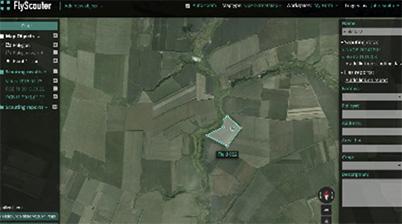

Increase yield and prevent losses
due risk detection on early stages

Save resources
due more accurate using of inputs. Crop health maps (NDVI, gNDVI and others) allow you use heterogeneity of soil fertility in the more effective

Saving efforts and time
in comparison with on-foots crop scouting. You can survey more than 100 ha per hour, dramatically improve your performanse and save time for productive work.

Saving money
in comparison with manned aircraft crop scouting. Rent of manned aircraft costs more than 1500 EUR per hour

More operative and precise
in comparision with satelite. Gives precision up to 2 cm on pixel

Easy of using
no special technical skills, no drones, no training, computers and additional pesronnel

Superior quality
and 100% correspondence with reality

Safety
we are using leading cloud data centers to provide your confidentiality and security
Write us
[email protected]Also you can contact us here
Telegram: SkyglyphVisit us
36 Vitosha Blvd., apt. 8More about on social media


