ROI of drones using in agriculture

Share this article to:
Victor Yermak

We are impatiently waiting for releasing of Ag ROI Calculator from Measure32 (https://lnkd.in/eyjh8wZ).

“The ROI Calculator™ estimates that for farmers using Drone as a Service® to enhance crop scouting, for example, ROI is $12 per acre for corn, $2.60 per acre for soybeans, $2.30 per acre for wheat”, – said FactSheet from company.

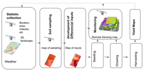
It will be very interesting to see how they select drone inputs from the whole process of precision agriculture:

Рисунок11-300x139

Share this article to:

Sample posts

How data fusion can improve crop insurance

Role of modern crop insurance in agriculture and its challenges The agriculture sector is a cornerstone of numerous economies worldwide, significantly contributing to food security and employment. However, it is intrinsically susceptible to a myriad of adversities including climatic anomalies, pests, diseases, and market fluctuations. Crop insurance emerges as a quintessential mechanism to cushion farmers […]

Forests are under threat. Forestry Insurance webinar announcement

Forests cover more than 30% of our planet’s whole area. Forests clean our air and water, give us work, protect, and even enable life itself. As usual, we do not value what we have. Everyone has heard of deforestation, illegal logging, forest degradation, and nature/human-caused catastrophes, lead to a rapid decline in the forest area. […]

Cooperation with Planet helps Skyglyph to accelerate the whole business cycle of serving customers

Skyglyph, a provider of aerial intelligence platform for agriscience, announces a partnership with Planet, largest earth observation satellite network delivering daily global datasets. The target auditory includes crop protection, seeds, agrochemical companies, and their distributors. The model of Skyglyph supposes to deliver composite analytics through the platform to customers: from satellites, drones, and even smartphones […]

Contacts